Located in the tri-state area of
Connecticut, New York, and
Massachusetts, Mt.
Frissell is an
interesting spot. The highest
point in Connecticut lies a couple
hundred feet down the south slope
of Mt. Frissell's summit. The
Connecticut high point is 2,380
feet but the summit of Frissell
(2,453 feet) is in Massachusetts.
Most people assume Bear Mountain
in Salisbury is the highest point
in Connecticut but it's about 50
feet shorter than the high point
on Mt. Frissell's south slope.
Makes you wonder why they just
didn't give Connecticut the peak
of Frissell since Massachusetts
has plenty of peaks taller than
Mt. Frissell!
Mt. Frissell is a popular
destination for serious hikers,
"high point" enthusiasts, and
state boundary fanatics. The
average day-hiker wouldn't go out
of their way to visit Mt.
Frissell...and for good reason.
It's a nice spot but there are
dozens of better sites to visit
that surround Frissell (Mt.
Alander, Bish Bash Falls, Bear Mt,
Sages Ravine, Mt. Brace are a
few). Of the hikers that venture
off to Frissell many are the "high
point" enthusiasts who are trying
to visit all the highest spots in
all 50 states. Others like to find
the old tri-state marker (1896
according to the engraving) that
marks the spot where CT, NY, and
MA meet.
When you scale Mt. Frissell you're
not going to get awesome views
from its peak. In fact you won't
get any views since the top is
densely forested. There is a neat
little book/diary that someone has
fastened to a tree in order to
mark the peak of Frissell and you
are encouraged to sign in with any
comments. It's fun to peruse the
diary and read the comments of
different people.
(March 2004 Update:
Ted Rybak found this page
via an Internet search and
informed me that for the past 20
years he has been the keeper of
the logbook at Frissell. Though
he's now working in Michigan he
still makes pilgrimages back to
Mt. Frissel to maintain the book.
Another visit is planned for March
'04. It was great to hear from him
and have him explain some of the
history of the logbook and
Frissell in general. It seems that
Dave Ceratta started the logbook a
couple years before Ted took over.
Ted discovered the book at Frissel
and wound up calling Dave after
seeing his contact info on the
inside of the logbook. Dave
explained that he was no longer
able to keep the logbook current
so Ted offered to take over. Great
stuff. There are a small band of
folks out there that make hiking
possible (volunteering, activism,
conservation) and give it a sense
of adventure (i.e. the logbook at
Frissell). I agree with Ted when
he described the Mt. Riga/Mt.
Washington region that Mt.
Frissell sits in: "The area up
there is certainly magical! I
believe it to be a power center
for positive and spiritual
energy. I'm sure the Native
Americans viewed it as such
also." It's really true.
Hard to believe it's just a few
hours from NYC and Boston. If you
ever signed the book, remember Ted
from years past, or just have a
question about Mt. Frissell that
he knows so much about, I asked if
I could post his email address and
he said that would be fine: tkrbmc@yahoo.com).
Mt. Frissell's peak doesn't
offer spectacluar 360 degree
views (although Ted did point
out that the views weren't as
limited as I may have led on
since trees have been cleared
for the views), there are some
nice overviews along the way to
Frissell via Round Mountain and
from certain vantage points
along Frissell's mountainside.
The area that surrounds Frissell
is beautiful. Flora
and fauna dominate.
It's all part of a region
known as the Taconic Plateau
and the forests surrounding
Frissell are part of Mt.
Washington Reservation, Mt.
Riga Reservation, and the
South Taconic Trail. Various
groups have worked hard to
preserve the area and as a
result it's about as remote as
you could feel within the
state of Connecticut. The
forest is very thick here and
when you hike down in between
hilltops and stop for a
moment, the only thing you'll
hear is the ringing of silence
in your ear...and the
occasional passing plane. It's
very rare in this part of the
country that you can stand
somewhere and not hear a
distant car, lawn mower,
motorcycle, leaf blower, etc.
Absolute silence is tricky
these days but it's possible
here.
There are several ways to
access Mt. Frissell but
Berkshire Hiking is
recommending the Mt.
Washington Road trail head on
the Connecticut/Massachusetts
border. It's just the easiest
way to get you to a trail
head. (If you're the type that
likes to hike all day, perhaps
you could start out on the
South Taconic Trail from Bish
Bash Falls and hike south to
Mt. Brace and then head over
to Mt. Frissell. Or stop at
Mountain Washington
Reservation ranger station
that's about a mile before
this suggested trailhead. Take
note of the trail system
posted there and take on the
Mt. Alander to Mt. Brace. to
Mt. Frissell loop...but be in
really good hiking shape if
you attempt this!). Anyway
you decide to go, you must
be in good shape for this
hike. It's not for beginners
or those who are out of
shape. You'll be very
isolated here and if you get
in trouble because you've
overestimated you're
abilities, you could find
yourself in a sticky
situation.
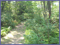
Once you reach the trail head
(driving directions are below)
via Mt. Washington Road you
immediately are immersed into
thick forest with dense ground
cover. Lush bushes, ferns,
plants, wild berry bushes
cover the forest floor;
hardwoods and pine trees
complete the canopy. Depending
upon your pace, you can expect
to reach the top of Frissell
in about 30 minutes to 1 hour
after leaving the trail head.
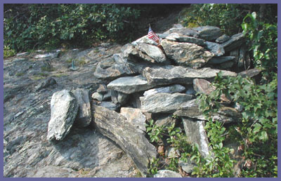
About 15 minutes into the hike
a short but steep section
takes you to the top of a hill
(Round
Mountain)
with some cozy spots and
nice overviews. Hikers seem
to go a little overboard
with the small rock piles
they are erecting but it
does add an interesting
human touch in an area
dominated by nature. Many
folks mistake this as Mt.
Frissell but the larger
mountain just to the
northwest is Mt. Frissell.
Keep an eye out for a side
trail that goes up to the
right as you near the
summit. This path leads to
the book/diary marking the
top of Frissell. You can
stop in to read the booklet
but if you're not into that
kind of stuff there really
is no reason to head up this
trail. As noted, there are
no great views from the peak
of Frissell. Continue on the
main trail and as it begins
to descend you'll come upon
a rock pile that hikers have
built and next to that is a
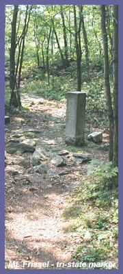
small surveyor's marker that
notes the CT/MA state
borderline (the main photo
above shows the short
greenish pipe sticking up on
of the ground to the left of
the rock pile). This spot
marks the highest point in
the state of Connecticut.
It's very strange that there
isn't an official (or
unofficial) sign indicated
the high point (maybe
Connecticut is embarrassed
that its highest point is on
the side of a Massachusetts
mountain?!). Anyway, once
you have conquered the
highest point in CT,
continue down until the
trail starts to flatten out
again. Soon you'll come upon
the stone pillar that marks
the spot where CT, NY, and
MA meet. It's about 3 feet
tall and you can't miss it
since it stands right on the
trail (the photo to the left
shows the tri-state marker).
And just as it's strange
that there is no official
notification of the CT high
point, it's strange that CT
was left off the engraving
on this pillar. NY and MA
are clearly engraved on
their sides but someone
(likely a passing hiker with
a rock) took the time to
scratch out "CT" on the
Connecticut side.
If you've had enough at this
point you should turn around
especially if its late in
the day. But if you're
feeling good, hike another
20 minutes or so to Brace
Mt.
in NY state. Great views
from there (crystal clear
days reveal the Catskills
looming off in the
distance) and also a
plateau region just before
Brace that is fun to
explore. To get to Brace,
just follow the trail
passed the tri-state
marker and when you come
upon a trail intersection
keep going straight.
(Going left takes you into
the Mt. Riga preserve and
right takes you back to
the Mt. Washington
ranger's station.) The
trail eventually meets the
South Taconic Trail. Where
these two trails meet is a
nice hilltop
plateau
that is reminiscent of
certain spots in Ireland
(a great spot for a
lunch break or long
rest). Take a right if
you want to investigate
this area or go left and
up to Mt. Brace where
you'll clearly note its
peak with a large rock
pile and grassy peak.
The views from Mt. Brace
are fantastic.
 Directions: Get
on Route 41 in
Sheffield, MA (41 heads
north out of Salisbury,
CT and south out of
Egremont, MA.). Just
south of Egremont, MA.,
Mt. Washington Road is
off of Route 41 (left
side of road if you're
heading north, right
side if you're
southbound). Take Mt.
Washington Road all the
way up the mountain and
it will eventually
flatten out. Eventually
you'll pass Mt. Everett
State Reservation on
your left and then a
short distance later Mt.
Washington State
Reservation on your
right. (As you proceed
through here you'll come
upon an intersection
with a white church and
you just want to
continue straight...DO
NOT follow the sign to
Bash Bish Falls towards
Copake, NY.). Mt.
Washington Road becomes
East Street. East Street
passes by homes and
wooded area and becomes
a dirt road. Follow this
road to the
Connecticut/Massachusetts
border. Directly across
the street from the road
sign and border
marker
is a small grass
parking area. Red
paint marks note the
trail to Mt. Frissell.
A short distance after
you begin hiking, the
trail turns
left...keep your eyes
open and follow the
red markers to the
left and don't
continue straight. (If
grass parking lot is
full, about 50 feet up
the dirt road is a
larger dirt lot with a
big AMC sign. This is
the lot to hike Sages
Ravine, Bear Mt., the
Appalachian Trail and
other great hikes. Mt.
Washington State
Forest is also a good
staging ground for
many hikes in the
area. Visit the official
website for Mt.
Washington as it
also has a map online
of the area. Download
it so you'll have a
copy.
Directions: Get
on Route 41 in
Sheffield, MA (41 heads
north out of Salisbury,
CT and south out of
Egremont, MA.). Just
south of Egremont, MA.,
Mt. Washington Road is
off of Route 41 (left
side of road if you're
heading north, right
side if you're
southbound). Take Mt.
Washington Road all the
way up the mountain and
it will eventually
flatten out. Eventually
you'll pass Mt. Everett
State Reservation on
your left and then a
short distance later Mt.
Washington State
Reservation on your
right. (As you proceed
through here you'll come
upon an intersection
with a white church and
you just want to
continue straight...DO
NOT follow the sign to
Bash Bish Falls towards
Copake, NY.). Mt.
Washington Road becomes
East Street. East Street
passes by homes and
wooded area and becomes
a dirt road. Follow this
road to the
Connecticut/Massachusetts
border. Directly across
the street from the road
sign and border
marker
is a small grass
parking area. Red
paint marks note the
trail to Mt. Frissell.
A short distance after
you begin hiking, the
trail turns
left...keep your eyes
open and follow the
red markers to the
left and don't
continue straight. (If
grass parking lot is
full, about 50 feet up
the dirt road is a
larger dirt lot with a
big AMC sign. This is
the lot to hike Sages
Ravine, Bear Mt., the
Appalachian Trail and
other great hikes. Mt.
Washington State
Forest is also a good
staging ground for
many hikes in the
area. Visit the official
website for Mt.
Washington as it
also has a map online
of the area. Download
it so you'll have a
copy.
Printable
version of the Mt.
Frissell page
|