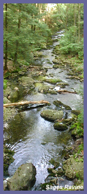
Sages Ravine
tumbles down a beautiful section
of forest and rock along the
extreme western tip of Connecticut
and Massachusetts' borderline.
When there has been a lot of rain
or snow melt, the series of falls
and cascades are breathtaking.
Even during times of drought a
quiet, peaceful world can be
found. Dark forest and steep hills
nearly cover the ravine and the
splicing of sunlight through the
trees only adds to the drama.
Though not the Grand Canyon by any
stretch of the imagination, Sages
Ravine is truly unique around
these parts and a must-see spot
for all hikers. And if you happen
to be there on a day when there
aren't other visitors, you'll feel
a lot more remote than you
actually are.
The Appalachian Trail runs
alongside the ravine and this
section of trail is popular and
well known to most seasoned
hikers. Like other spots in this
particular region (Bear Mountain,
Mt. Alander, Sages Ravine, Mt.
Brace) there are numerous ways to
access Sages Ravine but I'll
highlight two different
paths...moderate and strenuous.
I'd suggest that 90% of the people
should choose the moderate route.
But those who are in great shape
or looking for challenging hikes
would enjoy the strenuous route.
If you want strenuous, start at Undermountain
Trail.
Follow Undermountain to Paradise
Lane Trail and then hop on the
Appalachian Trail down to Sages
Ravine. On your way back to the
ravine (or your way there),
incorporate Bear
Mountain into the hike.
Bear Mt. is Connecticut's
highest peak and the views are
fantastic (Bear Mt. is the
highest peak but the highest point
in Connecticut is on the side of
nearby Mt.
Frissell, whose peak lies
in Massachusetts).
The moderate hike requires a
drive all the way to the top of
Mt. Washington Reservation and
eventually along a rugged dirt
road to the trail head. Round
trip, it could add 30-40 minutes
extra driving time than
Undermountain Trail but it's a
lot easier to hike. Accessing
Sages Ravine this way allows you
to hike down to the ravine in
about 20-30 minutes depending
upon your pace and then back up
to your car. The hike back to
the car will be strenuous for
some but should be manageable
for most...just take your time
if you get winded. From the
parking area (driving directions
to trail head are below) you
hike in along a trail maintained
by the Appalachian Mountain
Club. This section of trail is
real nice and gets you in the
mood for the ravine. The
hardwoods and lush undergrowth
create a serene world and the
path is flat which allows you to
loosen up before you descend to
the ravine. About 10-15 minutes
into the hike you meet up with
the Appalachian Trail. A small
wooden plank
(footbridge) marks the spot
(some folks may walk right
passed the Appalachian Trail
without realizing it). Take a
left (north) onto the
Appalachian Trail (The A.T.
can be noted by the white hash
marks painted on trees, rocks,
and stumps). If you were to go
right, you'd go up to Bear Mt
via the Appalachian Trail. But
going down the trail towards
the ravine is where you'll
want to go. A short distance
later you'll come upon another
trail intersection. Paradise
Lane Trail joins the
Appalachian Trail. It goes to
the right and eventually meets
up with Undermountain Trail.
But again, you'll stay left
and continue down. Be
careful as you hike down
into the ravine. The trail
is rugged and steep at
times. The trail is covered
with rocks and tree
roots/stumps. It can be a
little
hazardous...especially when
it's wet from rain, ice, or
snow. You could twist an
ankle or slip if you didn't
have proper hiking boots or
you weren't used to this
type of hiking. But if you
take it slow and pay
attention to trail you won't
have anything to worry
about...hard to do as the
scenery becomes more
enticing!
At the top of Sages Ravine is
a first come, first served
campsite if you are at all
interested in backpacking in.
This is a great spot to
overnight and hike to nearby
spots (Mt. Frissell, Brace Mt,
Bear Mt., Race Mountain, Race
Brook Falls, Mt. Everett, Jug
End). I asked a hiker about
the campsite and he said that
a black bear as recently
become "people friendly" and
will scavenge garbage or food
that isn't properly concealed.
(Fortunately for him, he had
cool dog who also had his very
own backpack and didn't
particularly like bears!) From
the top of the ravine to the
bottom is a couple hundred
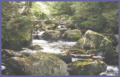
feet. The ravine tumbles
through this region
and the trail follows right
alongside the cascading
waters, streams, pools,
etc., and offers endless
spots to check out and
enjoy. Huge rock formations
have been carved out and
offer unique vantage points.
Since I'm suggesting you
hike here, I'll also make
sure to warn you about
this section. There's
something about the ravine
that is enticing. It just
invites you to play in and
around it...and that's
especially true if you
intend to bring children.
Most people want to get as
close as possible and
maybe jump around on rocks
as water rushes by and
tumbles down. Some no
doubt will dive into the
whirlpools during the
summer months. This could
be dangerous if you let
your guard down. A large
jumble of massive rocks
and rushing water can be
deceptively powerful so
please use good judgment
here.
When you reach the bottom of
the ravine and you know the
hike back up with be a piece
of cake, consider hiking on
to Laurel Ridge campsite
(formerly Bear Rock Falls)
or even Mt. Race for some
spectacular views of the
eastern valley. (There's a
trail sign at the bottom
that gives distance in miles
so you can gauge round trip
mileage.) But if you already
feel like you've been worked
out it's best to make your
way back to the car. The
hike over to Laurel Ridge is
mostly flat, very peaceful
and serene due to the large
hardwoods and pines that
tower over you. When you
reach the Laurel Ridge area
the campsite is on the left
and over on the right is a
rock ledge with an amazing
view and a small waterfall
that you can hear but can't
see due to the fact that the
water falls off the cliff
and into the forest below. Like
a dad who annoyingly
reminds you to check your
oil, etc., or a mom making
sure you're dressed for
the weather, I would like
to point out two things
about Laurel Ridge. One,
they are trying to restore
the forest in certain
areas so please respect
their wishes and stay out
of areas that are marked
as off limits for now. The
people who have worked to
preserve this part of the
state and the trails know
what they are doing and
why. They deserve our
help. They don't ask for
much and the requests are
reasonable. The only way
to keep it like it is for
generations to come is to
be a part of the
preservation effort. So
please respect all signs
posted in the area. Two,
the rock ledge is a
beautiful spot but
potentially dangerous.
There is plenty of room to
sit, relax and take it all
in. You couldn't ask for a
cooler spot to chill out.
There's also a sheer drop
off that could be fatal if
you ventured to close to
the edge...if you survived
a fall here you can cancel
any plans you've made over
the next few months
because you'll be in
physical therapy
recovering from massive
injuries. The tiny
waterfall that can't be
seen but heard might be
too tempting for some.
Trying to creep up to see
the water fall into the
forest below or a "what's
the big deal" attitude is
how people get their names
in the paper for all the
wrong reasons. I don't
mean lecture or come
across as the "trail
police". As someone who
encourages you get out and
enjoy nature, I also worry
that you'll get hurt doing
something I suggested.
Because we live in a
region that doesn't have
massive cliffs or
thousand-foot drop offs
that would terrify any
sane person, some people
get lulled into a falls
sense of security while
bouncing around the hills
of southern New England.
This is one of those spots
that should get your
attention. So just sit
back, relax, and enjoy one
of the best spots around!
And who knows, if you sit
still like I did, a bird
I've never seen in my life
might come flying right up
to you and sit on a branch a
couple feet away...as if to
say "pretty cool spot...huh
dude?". It must have been
migrating south (September)
and it literally did an
about face in mid-flight
when it saw me. Swooped in
on a branch hanging over the
cliff and then bounced along
a series of branches until
it was ten feet away. Looked
at me. Looked out over the
valley. Looked at me again
and stayed there for about a
minute. When I lifted my
camera to film, off he/she
went.
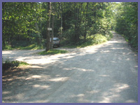 Directions:
Get on Route 41 in
Sheffield, MA (41 heads
north out of Salisbury, CT
and south out of Egremont,
MA.). Just south of
Egremont, MA., Mt.
Washington Road is off of
Route 41 (left side of road
if you're heading north,
right side if you're
southbound). Take Mt.
Washington Road all the way
up the mountain and it will
eventually flatten out.
Eventually you'll pass Mt.
Everett State Reservation on
your left and then a short
distance later Mt.
Washington State Reservation
on your right. (As you
proceed through here you'll
come upon an intersection
with a white church and you
just want to continue
straight...DO NOT follow the
sign to Bash Bish Falls
towards Copake, NY.). Mt.
Washington Road becomes East
Street. East Street passes
by homes and wooded area and
becomes a dirt road. Follow
this road to the
Connecticut/Massachusetts
border. About 100 feet after
the road
sign and border marker
is a large dirt lot with a
big AMC sign. This is the
lot to hike Sages Ravine,
Bear Mt., the Appalachian
Trail and other great
hikes.
Directions:
Get on Route 41 in
Sheffield, MA (41 heads
north out of Salisbury, CT
and south out of Egremont,
MA.). Just south of
Egremont, MA., Mt.
Washington Road is off of
Route 41 (left side of road
if you're heading north,
right side if you're
southbound). Take Mt.
Washington Road all the way
up the mountain and it will
eventually flatten out.
Eventually you'll pass Mt.
Everett State Reservation on
your left and then a short
distance later Mt.
Washington State Reservation
on your right. (As you
proceed through here you'll
come upon an intersection
with a white church and you
just want to continue
straight...DO NOT follow the
sign to Bash Bish Falls
towards Copake, NY.). Mt.
Washington Road becomes East
Street. East Street passes
by homes and wooded area and
becomes a dirt road. Follow
this road to the
Connecticut/Massachusetts
border. About 100 feet after
the road
sign and border marker
is a large dirt lot with a
big AMC sign. This is the
lot to hike Sages Ravine,
Bear Mt., the Appalachian
Trail and other great
hikes.
Printable
version of the Sages
Ravine page
|