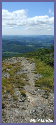
Mt. Alander
- Climbing the trail to the top of
Mt. Alander for the first time on
a clear day is an experience
you'll never forget. Awesome is a
word used too often in today's
society when people are describing
things that are "fun" or
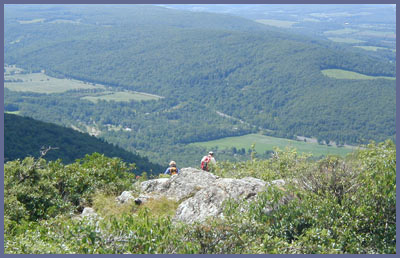
"exciting". The views from Mt.
Alander are awesome in the true
sense of the word! There may be
other mountains in the Berkshires
with similar views, but none could
exceed Alander for sheer viewing
pleasure. If you are like me and
hike to get a good workout
rewarded with spectacular views,
then you have to hike Mt. Alander.
You can easily see a hundred miles
in each direction if you hike on a
clear day. There are many ways to
summit the Mt. Alander and I took
the Alander Brook Trail access
with my brother who got me started
hiking as a little boy over 25
years ago. The both of us were
completely taken off guard by the
views that unfolded before us. We
had never known of the trail
system at Alander...I had climbed
nearby Mt. Everett and explored
Mt. Riga and the Appalachian Trail
nearby.
The hike from the dirt parking lot
to the summit is 2.5 miles and
it's pretty much straight up all
the way so you have to be in
decent shape to attempt it. You
follow the Alander Brook Trail to
South Taconic Trail then follow
the white hash marks north of
South Taconic Trail to the summit
of Mount Alander (2,250 feet)
Total elevation gain from parking
lot to summit is about 700 feet.
You should buy a map and bring it
if you aren't familiar with the
Taconic Plateau and Mount
Washington State Forest region.
It's a very simple trail system to
follow but it could be confusing
to some accessing South Taconic
Trail via Alander Brook Trail. AMC
Massachusetts and Rhode Island
Trail Guide (7th or 8th edition)
is a good book that has a map of
this trail system. A map called
South Taconic Trails by NY-NJ
Trail Conference is also a great
map. Google or Amazon.com should
bring them up for you to see where
you can purchase them.
Though never treacherous or severe
in its slope, the trail rises
through the forest in a manner
that doesn't offer many flat
sections. It can also be quite
rocky as you near the summit. If
you haven't been hiking in a while
or are not in the greatest shape,
you'll need to take it slow and
rest a few times. But patience and
persistence will pay off...I
guarantee it. If you aren't
thrilled with the views from atop
Mt. Alander, there's no hope for
you! From Alander you can see Mt.
Greylock due north, Albany (80
miles away) north west, Mt.
Everett east, and the Catskills
west. The valleys below offer
endless sites; farmland, forest,
ponds, lakes, etc. The top of the
mountain is a hikers playground.
You can stretch out on some soft
grass and watch the world go by,
take a nap as the sun warms you
up, stand on a number of rock
"podiums" and strike the classic
hiker pose as you look out over
the valley below, follow the
flight of a red-tail hawk, or pick
some wild berries. My brother and
I ran into a married couple from
Switzerland who had come out to
this region to pick wild mushrooms
to help them create special soups
and sauces. They assured me that
the Swiss Alps are absolutely
spectacular but that Mt. Alander
is a real sight to behold no
matter what you compare it to.
They spoke of the variety of
landscape in the Taconic Plateau
that can't be seen in the Alps. We
also met another married couple
who are spending their retirement
years hiking the Appalachian
Trail. They also pointed out that
the Mt. Alander section of the AT
is as good as any you'll see on
the trail. The Nature Conservancy
has listed the Taconic Plateau
region where Connecticut,
Massachusetts, and New York meet
as one of the last great places on
earth. Hike Mt. Alander and you'll
see why.
 Directions:
For those coming from NYC or
southern Connecticut take 84 west
to the 684/Rt. 22 exit in
Brewster. Take Rt. 22 north all
the way to Millerton, NY (about 55
miles) Stay on Rt. 22 north as it
heads up into Columbia County and
the approaches town of Copake, NY.
A few miles after crossing over
Columbia County line (but before
Copake) you'll pass some beautiful
farmland on your right hand side.
You'll see a golf course in the
"Boston Corner" region of this
area. A short distance later Under
Mountain Road will be a right hand
turn that you need to take. Not
quite a mile (0.8 to be exact)
down Under Mountain Road on your
left hand side will be a dirt
parking lot that is very small and
easily missed if you are driving
to fast. The dirt parking lot
cutout is just after a cornfield
following a long stretch of road.
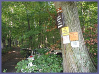
A large tree has signs posted
signaling the trail head.
Directions:
For those coming from NYC or
southern Connecticut take 84 west
to the 684/Rt. 22 exit in
Brewster. Take Rt. 22 north all
the way to Millerton, NY (about 55
miles) Stay on Rt. 22 north as it
heads up into Columbia County and
the approaches town of Copake, NY.
A few miles after crossing over
Columbia County line (but before
Copake) you'll pass some beautiful
farmland on your right hand side.
You'll see a golf course in the
"Boston Corner" region of this
area. A short distance later Under
Mountain Road will be a right hand
turn that you need to take. Not
quite a mile (0.8 to be exact)
down Under Mountain Road on your
left hand side will be a dirt
parking lot that is very small and
easily missed if you are driving
to fast. The dirt parking lot
cutout is just after a cornfield
following a long stretch of road.
A large tree has signs posted
signaling the trail head.
If you're coming from the north
(New York State or Massachusetts)
find your way to Route 22 and the
town of Copake. Head south on
Route 22 from Copake and Under
Mountain Road will be on the left.
You can also map search
and type in Under Mountain Road,
Copake, NY. for custom directions
on how to get to Under Mountain
Road. There are other options as
far as hiking up Mt. Alander. One
way is to start at Bash
Bish Falls State Park and
follow the South Taconic Trail up
to the peak. Maps are needed if
you haven't ever been here or
hiking without a local who has
been there (see the 2nd paragraph
above for map info). Another way
would be to start at Mount
Washington State Forest and
hike in from there. There's a
large trail map at the trail head
that shows you the way. This last
option is somewhat easier than the
Undermountain Road option but Bash
Bish option is probably the
hardest of them all.
Printable
version of the Mt. Alander
page
If you have any trail updates to
share or have feedback/questions
please click
here to send email or call
203.788.7665
|