"In the woods is perpetual youth" - Emerson
|
|
|
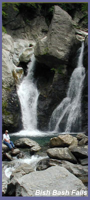
Bash Bish
Falls might be the most
spectacular waterfall in the state
Massachusetts. It's literally
located on the state line of NY
and MA in Mt. Washington, MA.
(It's a thirty second drive up
from Taconic State Forrest which
is in Copake Falls, NY.) Bash Bish
is an all-star attraction
guaranteed to satisfy. The falls
plummet through a series of
dramatic gorges before finally
cascading about 80 feet into
sparkling pools of water.
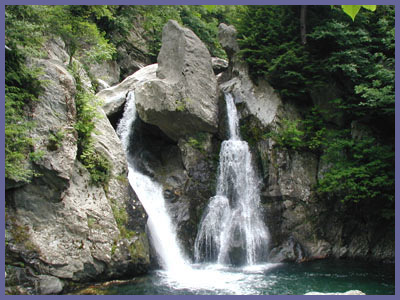
Even if there hasn't been
much rain, Bash Bish is still a
picturesque scene but when it has
received a lot of rain or snow
melts it's unlikely you'll see a
better waterfall in all of New
England. The trail leading
up to Bash Bish Falls runs along
the river that flows out and away
from the falls. It's a great
way to get some exercise and adds
a little drama to the experience
since you can hear the falls get
louder and louder as you close in
on them. The hike from the
main entrance to the falls is a
moderate distance, fairly easy for
those in relative good shape.
On the day I was there,
small children with their
grandparents had made it to the
falls without any problems.
There is a second way to
experience the falls by descending
the blue trail system to the
falls. This north entrance
above the falls is about a mile
from the main entrance on the
right hand side. You can't miss
the parking lot and cutout from
the road. Warning: Although
this area offers a great view of
the surrounding area and unique
views of the falls from above,
it's also potentially dangerous
as the small summit is jagged
rock and can be very slippery.
The DEM have constructed a
strong wire fence to keep folks
away from the sheer drop offs,
but it's still a scary place to
bring children or anyone who is
a novice hiker. If you try
the upper north entrance and
it's your first time there,
please be very cautious with
each step you take. You could be
critically injured...or
worse...if you got too close to
an edge. Please stand back and
enjoy it what is presented to
you...don't go that extra 10
feet just for the thrill.
Bash Bish Falls is a great place
to explore a running river
ecosystem and picturesque
waterfalls as they tumble through
a deep green forest. As noted
before, any waterfall is best
experienced if the region it's
located in has received a decent
amount of rain or snow melt.
(Verified page info: March 2015)
Click
here if you're interested in
getting a guided hike in this
region.
 Directions:
For those coming from Connecticut or
NYC area it's best to get on Rt. 22
north as it heads up New York along
the Connecticut/Massachusetts
border. Keep on Rt. 22 north
and you'll eventually come to
Copake, NY which is located where
New York, Connecticut, and
Massachusetts borders meet.
Proceed through the town of
Copake and soon you'll approach the
town of Copake falls. As you
near Copake Falls, Rt. 344 east
meets Rt. 22. Take a right onto Rt.
344 (east) and follow the signs for
"Taconic State Park" The
entrance to Taconic State Park is on
your left and the entrance to Bash
Bish Falls is about a mile up the
road from Taconic State Park.
(After you pass the entrance
to Taconic State Park the road comes
to a fork. Bear to your left at this
fork following the signs to the
entrance of Bash Bish Falls.) You
can also visit the
official website for Bash Bish
and get directions or other info
from there.
Directions:
For those coming from Connecticut or
NYC area it's best to get on Rt. 22
north as it heads up New York along
the Connecticut/Massachusetts
border. Keep on Rt. 22 north
and you'll eventually come to
Copake, NY which is located where
New York, Connecticut, and
Massachusetts borders meet.
Proceed through the town of
Copake and soon you'll approach the
town of Copake falls. As you
near Copake Falls, Rt. 344 east
meets Rt. 22. Take a right onto Rt.
344 (east) and follow the signs for
"Taconic State Park" The
entrance to Taconic State Park is on
your left and the entrance to Bash
Bish Falls is about a mile up the
road from Taconic State Park.
(After you pass the entrance
to Taconic State Park the road comes
to a fork. Bear to your left at this
fork following the signs to the
entrance of Bash Bish Falls.) You
can also visit the
official website for Bash Bish
and get directions or other info
from there.
If you have any trail updates to
share or have feedback/questions
please click
here to send email or call
203.788.7665
|
|
|
| |
All
code, graphics, multimedia, content copyright
Berkshire Hiking LLC |
|
|