NOTE: There seems to be every varying reports
about the summit road to Everett.
Their website states that the road
is open up to Guilder Pond during
warmer months. However, at times during summer
the road is closed at the base
parking. There seems to be an
ongoing discussion (friction?)
between reservation stewards and
state park system as to how the
state reservation should be
accessed. As a result, some
changes have taken place such as
tearing down the old fire tower on
top and closing all or part of the
summit road most of the year (if
not entirely depending upon who
you talk to). It's an amazing
place to hike around but you may
want to call/email ahead to get
the latest information (official
website). It's an out of the
way place so just be aware that
the long drive there could lead to
a closed summit road. As of this
writing (July 2010) their website
says the summit road is open
during summer. But you should
contact them first if you are
traveling far just to be safe.
Mount
Everett is located in
Massachusetts close by the
regional corner where Connecticut,
Massachusetts, and New York meet.
It's a long drive to Mount
Everett from Boston, southern
Connecticut, or NYC but the ride
is through some of the most
picturesque in Connecticut or New
York state depending upon which
route you decide. About 27,000
feet smaller than its Asian
cousin, Mount Everest, Mount
Everett requires a good amount
time and energy to hike up to its
2,624 foot summit. You'll
feel a mountain much bigger than
the one you're standing on.
The wind blows hard, the
trees' growth is stunted and
rugged looking, with views second
to none. If you hike in from
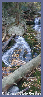
Race Brook Falls off of Route 41
in Sheffield, Massachusetts,
you'll hike by one of the most
picturesque waterfalls in the
Berkshires (Race
Brook Falls description).
That would be a very tough hike
for the average day hiker since
the total elevation gain would be
about 1,800 (trail head off Route
41 is about 800 above sea level).
The old firetower is torn down so
some think the views aren't work
the effort via Race Brook Falls
but it is peaceful at the summit
and plenty of spots around the
summit to piece together great
views in all directions.
If the summit road is open, you
can cheat by driving up the
mountain! There's a road nearly
all the way to the top with a
short walk to the peak. When the
road is closed, it's a shame for
those who can't hike to the summit
because in that region it was the
only place they could enjoy
amazing views that us hikers take
for granted. I've often thought
how many people would love to see
wonderful views but because of
physical limitations they can't.
It really is unfair for that
reason alone that the road has
been closed to the summit at
various times.
(Should the summit road be closed
you might want to check out Mt.
Greylock. About 45 minutes north
of Everett, Mount Greylock is off
Route 7 in Lanesborough. It's
Massachusetts' tallest mountain
and there's a summit road just
renovated in 2009. I'd highly
recommend Greylock since it's a
thousand feet taller and much more
spectacular. There are restrooms
and small cafe at the log cabin
gift shop (also has a rustic
hostel for over night hikers).
Greylock has a fantastic visitor
center to plan out your visit with
an incredible metal sculpture of
the parks mountains, trail, and
roads along with a friendly staff
to answer any question you may
have. Greylock's
official website)
If you are a seasoned hiker and
you want a high octane workout,
you should tackle the Race Brook
Falls to Mount Everett option.
You'd follow the BLUE trail system
(or red trail to the base of falls
is fine too since it meets back up
with blue trail at the top of the
falls) up and beyond the falls.
After the falls, the blue trail
becomes a flat through a very nice
forest section. The blue trail
markers are hard to spot in this
section but are clearly visible if
you look hard enough. You
shouldn't have trouble but some
people lose the trail up in this
section and get lost. But it
should be no problem for those
paying attention and eventually
the blue trail meets the
Appalachian Trail and its white
hash marks.
It's about a mile hike up the
eastern face of Everett to the
summit area from this trail
intersection. Where the Race Brook
blue trail meets the white trail
of the Appalachian Trail, you'd go
right (NORTH) to go to Everett.
(Going left would take you south
to Mount Race which also is a
gorgeous spot to visit. Trail
signs tell you the distances to
various spots including back
country campsite that are first
come-first served basis.) On the
eastern summit side of Everett are
really nice views back into
Connecticut and the Twin Lakes
region. At the peak, you'll need
to walk around the trails at the
summit to find different overviews
now that the firetower is gone but
the views are grand. Don't blaze
your own trails on the summit
since they are trying to protect
the landscape after years of folks
walking all over the place.
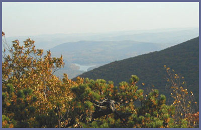
When the sky is clear you can see
very far: south into Connecticut,
west into New York state (the
Catskill Mountain looming in the
distance), north and east for a
great view of the state of
Massachusetts.
View
via Race Brook Falls access
| View
south on Mt. Everett
For most people who would be
up for a hike that is somewhat
challenging but not a
marathon, then park your car
at the base of the Everett's
summit road which is off of
East Street in Mount
Washington, Massachusetts.
East Street is a high
ridgeline road so you'd start
your hike at a higher
elevation to begin with. The
summit road will take you up
to Guilder Pond which has a
beautiful loop trail as a side
option. From Guilder Pond you
continue on the road until you
see the white has marks of the
Appalachian Trail. Hop on the
A.T. and head for the summit.
From Guilder Pond to the
summit is just under a mile in
distance. Or just continue
along the road and forego the
A.T. trail option and follow
the road to the old summit
parking. From there, a trail
to the summit still exists but
it might be hard to find and
follow so perhaps the A.T. to
summit is the better option.
From parking lot to
summit should take 45 minutes
to an hour, longer if you do
the Guilder Pond side loop.
A few rattlesnake sightings
have been reported through the
years. Though extremely rare
to actually see one, they do
inhabitat the area so it is of
course worth noting to keep an
eye on the trail where there
are sunny outcrops or grassy
areas where the cold-blooded
snake sunbaths.
Visit the official
website for Mt. Everett
for driving directions and
updated info. Just note in the
driving directions that Mount
Washington Road that is off of
Route 41 and heads up into the
mountains becomes East Street
at some point. Some folks
become confused when they
suddenly see East Street
addresses but Mount Washington
Road at some point high up in
the hills becomes East Street.
The address for Everett is 3
East Street, Mount Washington,
Massachusetts but the driving
directions tell you to follow
Mount Washington Road all the
way to Everett.
Printable
version of the Mt. Everett
page
|