"In the woods is perpetual youth" - Emerson
|
|
|
Brace
Mountain sits atop the
Taconic Plateau in New York right
next to the borders of
Connecticut, Massachusetts, and
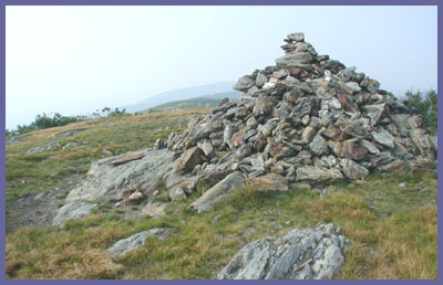
New York. The peak of Brace is
somewhat flattened out and
treeless so it makes for relaxing
views where you can find a soft
spot to sprawl out on and take in
the beauty of nature. You'll need
the rest as the hike to Brace will
get your blood pumping for sure.
From Brace there is a great scene
to the west. Brace hangs high over
the farmland and neighborhoods
dotting the valley below and
affords great views of the
mountain ranges in the distance
(Shawagunks across the valley and
the larger Catskills rising over
the Shawagunks...but you'll need
crystal clear days to see the
Catskills). Brace's eastern views
aren't bad either. Rolling hills
with nothing but trees is all that
you'll see. The lush forests of
Mt. Washington State Forest and
Mt. Riga Reservation are protected
from logging or development and
the results are fantanstic.
The South
Taconic Trail that runs
north/south for many miles along
the Taconic Range passes right
over Brace Mt. You can follow the
trail north from Brace and in a
few minutes find yourself standing
in a scene reminiscent of Ireland
or Scotland. The trail follows the
ridgetop with its open field look.
The
invite you to stroll around and
find a comfortable spot to rest.
Hawks and vultures use the
thermals rising up Brace's slopes
from the valley below so if you
lay back on a warm day you'll
likely get a lesson in
aerodynamics from these expert
gliders. In this region you'll
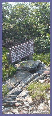
encounter a couple of trail signs
and depending on how you're
feeling you could incorporate
other hikes. Mileage is clearly
marked. Mt. Alander would add 5-6
miles roundtrip but the views from
Alander are breathtaking so if
you're a hearty soul looking for
an all day affair, give it a go. But
that's not a good idea at all
for a beginner hiker or someone
not in good shape.
The directions below are to access
Brace via Mt. Frissel Trail. You
could also access Brace from the
southern trailhead of the South
Taconic Trail but this would be a
much more strenuous hike. The Mt.
Frissel path already starts you
high up on the Taconic Plateau
whereas South Taconic Trail would
require a hike up the plateau
first and then up to Brace. Visit
the South Taconic Trail webpage
for driving directions and more
info.
 Directions: From Great
Barrington region: Get on Route 41
in Sheffield, MA (41 heads north out
of Salisbury, CT and south out of
Egremont, MA.). Just south of
Egremont, MA., Mt. Washington Road
is off of Route 41 (leftside of road
if you're heading north, rightside
if you're southbound). Take Mt.
Washington Road all the way up the
mountain and it will eventually
flatten out. Eventually you'll pass
Mt. Everett State Reservation on
your left and then a short distance
later Mt. Washington State Forest (official
website)
on your right. (As you proceed
through here you'll come upon an
intersection with a white church
and you just want to continue
straight...DO NOT follow the sign
to Bash Bish Falls towards Copake,
NY.). Mt. Washington Road becomes
East Street. East Street passes by
homes and wooded area and becomes
a dirt road. Follow this road to
the Connecticut/Massachusetts
border. Just to the right of the
is a grass parking area. The red
trail markers are for Mt. Frissel.
Follow that trail all the way over
to where it meets South Taconic
Trail (45 minutes - 1 1/2 hours
depending upon your pace). Signs
for Brace are clearly noted but
you just want to go left towards
the mountian top clearly in your
view. There are other ways to get
to Brace and you can click for the
official
Mt. Washington State Forest
map
to plan other routes. This will
open a new browser window and
you can right mouse click to
choose "Save As" and put a copy
on your computer.
Directions: From Great
Barrington region: Get on Route 41
in Sheffield, MA (41 heads north out
of Salisbury, CT and south out of
Egremont, MA.). Just south of
Egremont, MA., Mt. Washington Road
is off of Route 41 (leftside of road
if you're heading north, rightside
if you're southbound). Take Mt.
Washington Road all the way up the
mountain and it will eventually
flatten out. Eventually you'll pass
Mt. Everett State Reservation on
your left and then a short distance
later Mt. Washington State Forest (official
website)
on your right. (As you proceed
through here you'll come upon an
intersection with a white church
and you just want to continue
straight...DO NOT follow the sign
to Bash Bish Falls towards Copake,
NY.). Mt. Washington Road becomes
East Street. East Street passes by
homes and wooded area and becomes
a dirt road. Follow this road to
the Connecticut/Massachusetts
border. Just to the right of the
is a grass parking area. The red
trail markers are for Mt. Frissel.
Follow that trail all the way over
to where it meets South Taconic
Trail (45 minutes - 1 1/2 hours
depending upon your pace). Signs
for Brace are clearly noted but
you just want to go left towards
the mountian top clearly in your
view. There are other ways to get
to Brace and you can click for the
official
Mt. Washington State Forest
map
to plan other routes. This will
open a new browser window and
you can right mouse click to
choose "Save As" and put a copy
on your computer.
To start the trail at the
extreme end of Quarry Hill Road
in New York:
Get on Route 22 going
north/south in New York. Watch
for Whitehouse Crossing. Take
Whitehouse Crossing through some
farms until it ends at Boston
Corner Road. Take a left on to
Boston Corner Road, then a very
short distance up the road will
be Deer Run Road. Take a right
on to Deer Run which is a dead
end road but just before it ends
take a left on to Quarry Hill
Road. You'll go up and then bend
down to the right along Quarry
Hill Road. As it flattens out a
bit look to your left and you'll
see a sign for South Taconic
Trail and Taconic State Park.
It's across the street from a
house and just a barely visible
dirt/grass parking area.
Printable
version of the Brace
Mountain page
|
|
|
| |
All
code, graphics, multimedia, content copyright
Berkshire Hiking LLC |
|
|