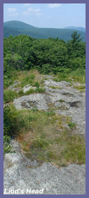
Lion's Head
in Salisbury, CT might have the
distinction of being the shortest
hike with the greatest views in
western Connecticut. Scramble up
the trail on a clear day, and
it'll seem like you can see the
entire state. This is the perfect
spot if you love overviews. Lion's
Head seems to hang over the valley
you hiked up from and it's a steep
drop-off at the summit area so
just be a little careful when
you're up there. You almost have
the sensation of looking straight
down into the immediate
surroundings. Then of course
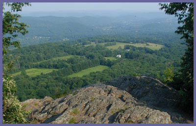
there's the long distance views.
The southern part of Connecticut
spreads out in front of you with
the rolling Litchfield Hills
south-southeast, Twin Lakes due
east, Massachusetts
north-northeast, and surrounding
mountainsides, farmland,
woodlands, and small towns filling
in the pieces. Click here
for a panoramic shot (these are
actually 8 photos pieced
together...for those with smaller
computer screens, you'll be
scrolling left and right to see
the whole scene...sorry but this
is best viewed a larger screen
with deeper resolutions).
Lion's Head (1,738 feet) is a
popular spot for locals but never
really crowded so there won't be
any problems as far as getting a
good vantage point or finding a
nice spot to take in the views.
The hike up to Lion's Head isn't
too bad although it's pretty steep
at certain points (just over a
half mile). The nice thing about
Lion's Head is that you drive up a
steep road to get to the trail
head so most of the tough stuff is
left behind you when you start
out. You'll start out by parking
in the dirt lot designated "Hiker
Parking" on the East side of Bunker Hill Road.
(Please respect the privacy of the
residents by sticking to the
designated parking lot even though
you might be tempted to drive up a
little further and park closer to
the trail head. There is no parking there.) You will park in the dirt parking area; there's a Trailhead Kiosk there at the start of the trail headed North. It has trail maps and other information.
The trail runs North from the lot and then East behind private property and crosses their driveway heading East.
Trail Signs are clearly marked where it crosses the private driveway. You will see a large Barn to the South (on your left) and a Small Grey building to the North (on your right).
Where the dirt road goes off to the right (North is private property), you'll want to go East (Signs Clearly marked) and follow the trail as it dips into the woods and goes along a stone fence initially.
There is no overnight parking at Lion's Head Trail.
The trail quickly takes you into
the cover of forest and begins to
rise straight off. If you're in
decent shape it's not a bad hike
at all but it's one that goes
straight up and doesn't stop
rising until you are near the top.
So if you're new to hiking or
haven't been out in a while just
take your time and rest at certain
points...and bring water so you
can re-hydrate and keep your
muscles from stiffening up. Don't
push it. The hike isn't long and
the view is the whole point for
going. Once you're up there, you
can relax and hang out for a good
long while and take in the
spectacular view.
As you near the top, the
Appalachian Trail appears on your
right and joins up with Lion's
Head trail (which is part of the
blue trail system...thus the blue
hash marks along the way). The
Appalachian Trail is marked with
white hash marks (usually on the
sides of trees) to guide the hiker
along. So from this point til the
peak you'll see a lot more white
hash marks than blue. (Just
remember that on the way back to
the car don't take a left onto the
Appalachian Trail or you'll go
completely out of the way).
Near the peak there will be a
small clearing amongst the
trees...almost looks like a
campsite. Here you can go right up
the rocks following the white hash
marks of the Appalachian Trail or
take a more roundabout but
physically easier route by
following the blue trail for a few
hundred yards and then doubling
back to the peak. The scramble up
the rocks really isn't too bad at
all but if you're worried about
slipping or something just take
the blue trail. Either way you'll
be rewarded with the same
spectacular view. And great views
they are! This really is a perfect
spot. It's almost as if there are
two separate scenes. The immediate
valley below you that you just
hiked from and the long distant
views that spread out all over.
(There are no western views at
Lion's Head so this is all
north-east-south scenery.)
Sunrises must be unreal.
After taking in the views you have
a few choices. You can head back
to the car. You can walk up a few
hundred yards along the
Appalachian Trail to neat little plateau
area that gives you a great
northerly vista. Or you can just
keep going along the Appalachian
Trial as it passes through
remote (for Connecticut anyway)
woodlands, past campsites used
by overnight hikers (check out
the shelter at Riga campsite for
a neat view of the eastern
valley. Not a bad place to catch
a night's sleep.), over
cascading rivers and small water
falls, and eventually up Bear
Mountain...the highest peak in
Connecticut. (You need to be in
good shape to venture off from
Lion's Head to Bear Mt. It's a
long hike and Bear Mt. can get
steep.)
Worth noting: from mid/late June
to early July, white
and pink mountain laurel
explode in this part of the
forest and is truly unique for
this region of the country.
The laurel fills in all around
the forest and emits a
wonderful fragrance.
 Directions:
Get to the center of
Salisbury, CT. Depending upon
which direction you're coming
from, that would be either
Route 41 or 44. Once in
Salisbury notice the Town Hall
across the street from the
library (which is a stone
building). At the Town Hall go
up Bunker Hill Road. Stay on
Bunker Hill Road (at places
where you are not sure if you
should go to the left or
right... just bare right) and
in 1 mile Bunker Hill Road
will end. As it ends you'll
clearly notice the dirt
parking lot labeled "Hiker
Parking". Park in here and
then walk up the road to the
trail head which is on your
left after passing the
satellite TV dishes.
Directions:
Get to the center of
Salisbury, CT. Depending upon
which direction you're coming
from, that would be either
Route 41 or 44. Once in
Salisbury notice the Town Hall
across the street from the
library (which is a stone
building). At the Town Hall go
up Bunker Hill Road. Stay on
Bunker Hill Road (at places
where you are not sure if you
should go to the left or
right... just bare right) and
in 1 mile Bunker Hill Road
will end. As it ends you'll
clearly notice the dirt
parking lot labeled "Hiker
Parking". Park in here and
then walk up the road to the
trail head which is on your
left after passing the
satellite TV dishes.
Printable
version of the Lion's
Head page
|