Hoosic Trail
is an old ridgeline path once used
by Native Americans to negotiate
the Berkshire Mountains. It?s a
small section of the Mohawk Trail,
a trading highway hundreds of
years old?older in fact than any
in town in Berkshire County.
Headed East on Route 2 you?ll
drive past the landmark ?hairpin
turn? and likely gasp in awe at
its sumptuous view of
Massachusetts and Vermont. Many a
motorist become distracted by the
non-stop sights so be wary as the
parking lot isn?t the most
conspicuous of places. You?ll know
you?re close when you hit a group
of cottages that appear to hang
off the edge of a mountain. The
parking lot is located across from
a large green highway sign, its?
entrance marked by a sign that
reads, ?Hoosic Trail? and
underneath ?BNRC?.
Headed West on Route 2 you?ll
drive through sparsely populated
hill towns and find the trail?s
parking lot across from a large
green highway sign before the road
pitches downward. If you begin to
descend the mountainside into
North Adams you?ve gone too far.
The trail officially opened only
recently, it?s owned and
maintained by Berkshire Natural
Resources Council, and if you
really want a treat try their
guided wildlife tours which they
offer seasonally. Visit bnrc.net
and bnrc.net/events for a hiking
guide or scheduled hiking events
(don?t miss the twilight bonfire
hike). Moose, deer, bear, fisher
cat, muskrat, and all other sorts
of critter visit the trail but
unless you?re a tracker it?s
difficult to pick out the signs.
The tours are free.
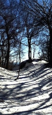
From the trailhead you?ll hike
over hardwood forest and small
streams for half a mile. The
starting elevation is already in
the clouds but the trail climbs
higher eventually reaching a fork
with a steep incline as the
backdrop. I?d suggest going left
toward ?sunset rock?, especially
if it?s that time of the evening.
The trail is comparably steeper to
its counterpart on the right but
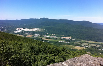
more enchanting. When you arrive
there?s a large ?window? with
views of North Adams,
Williamstown, and some of the
preambles to Greylock Mountain.
The path then follows a rolling
ridgeline which is occasionally
interrupted by walls of granite.
Look closely and you?ll find deep
grooves in the rock, 10,000 year
old striations from the retreat of
the last glaciers.
The trees are gnarled and dwarfed,
interesting looking beings that?ve
dealt with a mix of powder dumps,
freezing rain, plenty of sunshine,
and crisp clean air all year
round. Wetlands dot the landscape
so watch for frogs and salamanders
on the path and don?t forget the
binoculars.
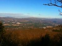
The trail finishes at Spruce Hill
where it intersects with Savoy
State Forest?s Busby Trail. From
there you?ll have views of
Greylock, the tallest mountain in
Massachusetts, and much of the
surrounding landscape. Especially
nice during the foliage season
this isn?t a trail to pass up.
Click
here if you're interested in
getting a guided hike in this
region.
 Directions:
Take RT-2, the trailhead is near the
border of Florida and North Adams.
If you have any trail updates to
share or have feedback/questions
please click
here to send email.
Directions:
Take RT-2, the trailhead is near the
border of Florida and North Adams.
If you have any trail updates to
share or have feedback/questions
please click
here to send email. |