How anybody got a hang glider up
to Hang
Glider View is beyond me.
Situated way up high along a ridge
top on the Appalachian Trail, deep
within a tall hardwood forest, the
climb up to the old hang glider
ramp couldn't have been easy. But
I will admit that the western
views of upper Litchfield County
would've easily inspired the
effort it took for a magnificat
flight back to valley far below.
The hang glider days are long gone
but the views are as good as ever
so you'll want to get up there,
take it all in, and imagine
yourself taking a leap of faith
and flying off the mountain.
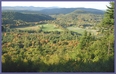
Hang Glider View is a spot
nestled along the Appalachian
Trail in Falls Village, CT.
Sitting on high the western views
here are classic southern New
England - rolling hills off in the
distance, open fields, forests,
farmland, cozy houses dotted
about, and a glimpse of the world
reknowned Lime Rock Racetrack.
Getting up there will take some
energy as it's a good little hike
with some steep sections but at
least it's easy to get there - hop
on the Appalachian Trail at the
intersection of Routes 7 and 112
and head south, following the A.T.
white hash marks, until you come
upon the old wooden hang glider
ramp.
Though Hang Glider View is the
obvious highlight of this hike,
there are several smaller
overviews along the way that are
terrific...just enough to keep you
inspired to make it all the way to
the ramp. It's not a marathon hike
but you can plan for one hour in,
one hour back...give or take a
half hour depending upon what kind
of shape you're in. Along with the
picturesque views the thick forest
cover creates a peaceful sanctuary
at various points along the trail.
At times, the massive pine trees
all bundled together will bring
you into some cool, dark spots
even during the brightest days of
the year. The sunlight trying to
shine through the thick canopy
will produce a golden glow
underneath the pine tree tops.
This trail is well known to
locals and A.T. thru-hikers so the
path is well maintained, worn, and
properly marked. Some sections are
rocky with loose stones but
overall the trail is clear and
smooth. However, danger lurks on
this particular stretch of the
A.T. You must keep your eyes
open for rattlesnakes...yes,
that's right...there are some
rattlesnakes in extreme
northwest Connecticut and this
is one of those isolated places
were they exist. Though I'd be
shocked if you actually saw one,
let alone found yourself within
striking distance, I
put together this page which
you should read before going
on a hike here. It has
basic info on rattlers and will
help you see there's no reason
at all to be afraid to hike
because of a fear of these
snakes. The page also has links
to other websites with more in
depth information on Timber
Rattlesnakes. I've never seen a
rattler in all my years of
hiking and seriously doubt you
will (though I did see an old
shedded snakeskin that was
clearly a Timber snake). But in
case you do have an encounter,
now you'll have an idea what to
do...or not to do.
Eventually you'll make your way to
Hang Glider View and you can't
miss the spot since where else
would you find a huge wooden ramp
suddenly appearing in the middle
of the woods! The views are great
and especially nice at sunrise or
dusk (although don't linger for an
entire sunset or you'll be hiking
back in darkness and that's never
a good idea...but especially true
in a place where rattlers
live...and in summer they come out
at night to hunt and try avoid the
hot summer day hours). Rolling
hills, open fields, thick forests
frames out the scene here and down
to the right you can clearly see
the far end of Lime Rock Racetrack
which adds an intriguing element
to the scene. So, suck up your
fear of snakes because there
really is no need to be afraid and
head on up to the forest and views
at Hang Glider View. I promise
that it will be well worth the
effort!
Directions: The
trailhead for Hang Glider is right
at the intersection where Routes 7
and 112 meet in Falls Village, CT.
Just north, a few hundred
feet, of the gas station is a dirt
parking lot right off Route 7 with
plenty of spaces for hikers (a
cornfield and farm are right
across the street). The white hash
marks of the Appalachian Trail are
easily seen and you just follow
the trail down to the Housatonic
River and walk along its banks as
the Appalachian Trail bends back
around to Route 7. You cross over
Route 7 (careful!...watch at for
fast cars) and the trail dips into
the woods again and begins to wind
up the mountain. Follow the
Appalachian Trail all the way to
Hang Glider View. Don't park in
the gas station.
Printable
version of the Hang Glider
View page
If you have any trail updates to
share or have feedback/questions
please click
here to send email or call
203.788.7665
|