|
Directions for southern Connecticut residents: Take Rt. 7 north to Kent.
Proceed through the town of Kent continuing on Rt. 7.
Keep following 7 north as you go through Kent and past Kent Falls State Park.
Soon you'll descend into the town border of Cornwall where you'll see little shops on your left and a motel and market on your right.
Rt. 7 bends to the left and comes to a stop. Keep bending to your left as Rt. 7 and Rt. 4 are the same road for about 100 feet.
Rt. 4 (keep bending to your left) goes up sharply and will eventually take you to the center of Sharon, CT.
From Sharon, Ct. take a right onto Rt. 41 north to Lakeville.
At the center of Lakeville take a right onto Routes 41 and 44 as they are the same road for a few miles.
(As you pass through Lakeville center keep a close eye out on the right side of the road for a "unique" fellow who always sits in his antique pick up truck.
He's usually across the street from the market/deli.
Send someone from your group over to ask for directions from this interesting old-timer.
He's always good for a few laughs and I promise you that he is totally harmless.
Toddlers may be frightened in the same way I thought Big Bird was the most terrifying creature on the planet when I was 4 years old so it's best if they just watch from a distance)
Proceed on this route north and take 41 north as it veers left at the White Bard Inn.
You're in the town of Salisbury as you proceed but soon you will cross the Massachusetts border and enter the town of Sheffield.
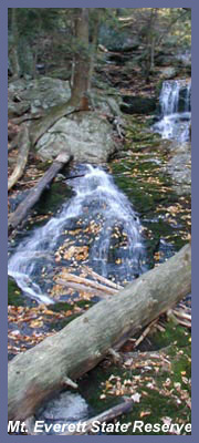
A short while later is the waterfall trailhead to Mt. Everett.
Stop here if you just want to see the waterfall or see the falls and take the strenuous hike to the summit.
If you want to drive to the top of Mt. Everett keep going on 41 north for quite and eventually you'll come to Mt. Washington Rd on your left.
There is a big pond just as you get onto Mt. Washington Rd.
From Salisbury to Mt. Washington Rd is 15-20 miles.
You'll proceed 7 miles on Mt. Washington Rd and you'll notice a steep incline.
The road flattens out eventually and you'll come upon Blueberry Hill Farm on your right.
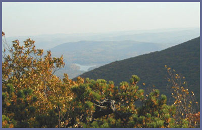
Two miles later you'll see the sign that says Mt. Everett State Reservation.
It's located on your left and you pull in at the sign.
Follow the dirt road all the way up to the peak.
If you want to hike the road park at the gate.
You can also go up to the campground area to park for a shorter hike.
From Danbury, CT the trip is about 100 miles to the top of Mt. Everett.
If you're in the mood for a nice ride and hike...it's definitely worth it.
WARNING: Sometimes in the summer months they close the road because of maintenance or because a
heavy rain has washed out parts of the road.
It's extremely rare but does happen. Call ahead.
If you have any trail updates to share or have feedback/questions please click here to send email or call 203.788.7665
|