|
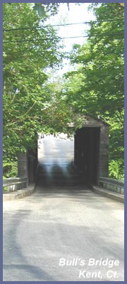
 Bull's Bridge
in Kent, CT. offers a wonderful
river walk with waterfalls,
rapids, overviews, a small gorge,
and if you're in decent shape a
picturesque overview high up
looking back over the river.
Part of the trail system
encompasses the Appalachian Trail
so you can follow the white marker
as long as you'd like...but
remember, you'd be heading south,
and the white markers don't stop
until you hit Georgia 2,000 miles
away! Bull's Bridge is a
great place whether you just want
to stretch your legs for a few
minutes or set out on a strenuous
hike. First thing you'll
want to do is take time to check
out the covered bridge, the old
power station and the waterfalls
cascading through the stmall
gorge. Local history has noted
that several versions of the
bridge have been built. Two
brothers from the Bull family
built an ironworks around 1740 and
likely a first version of the
bridge. Another story heard is the
most recent bridge design was
initially built mid-1800s to
attract New York City traffic
heading up state. Prior to the
bridge this region had no means of
getting traffic across the
Housatonic River in this region.
In 1917 Connecticut Light and
Power built the Rocky River power
station to harness the power of
the river. The dam/canal system
that creates the waterfalls and
rapids is part of the
hydro-electric power plant.
Bull's Bridge
in Kent, CT. offers a wonderful
river walk with waterfalls,
rapids, overviews, a small gorge,
and if you're in decent shape a
picturesque overview high up
looking back over the river.
Part of the trail system
encompasses the Appalachian Trail
so you can follow the white marker
as long as you'd like...but
remember, you'd be heading south,
and the white markers don't stop
until you hit Georgia 2,000 miles
away! Bull's Bridge is a
great place whether you just want
to stretch your legs for a few
minutes or set out on a strenuous
hike. First thing you'll
want to do is take time to check
out the covered bridge, the old
power station and the waterfalls
cascading through the stmall
gorge. Local history has noted
that several versions of the
bridge have been built. Two
brothers from the Bull family
built an ironworks around 1740 and
likely a first version of the
bridge. Another story heard is the
most recent bridge design was
initially built mid-1800s to
attract New York City traffic
heading up state. Prior to the
bridge this region had no means of
getting traffic across the
Housatonic River in this region.
In 1917 Connecticut Light and
Power built the Rocky River power
station to harness the power of
the river. The dam/canal system
that creates the waterfalls and
rapids is part of the
hydro-electric power plant.
Most will come to the bridge via
Route 7 (visitors coming from New
York may arrive via Route 22, then
Route 55, then past Webetuck
Village complex, so just be aware
and reverse these instructions if
you happen to come that way). From
Route 7 you dip down left towards
the bridge. It's a one-lane bridge
and those coming in the other
direction DO NOT have to stop but
you will have a stop sign so you
must yield to them and allow them
to pass through the bridge first.
Just out the other side of the
bridge is the main parking lot on
your right (you can park anywhere
along the road if the lot is full
and in spots where there aren't
"no parking" signs. From the main
lot you can visit the falls area
by hiking the trail that's between
the parking lot and covered bridge
on the north side. Use
caution hiking near falls in
this area since trail erosion
and varying water heights could
make it dangerous up close. DO
NOT get right up to river's edge
or out on rocks if rapids are
strong or you may be taken out
in a body bag a mile down river
- if they find you. It's amazing
to see people, and especially
those with kids, put their feet
right next to a raging river
rapid or even hop onto a rock
just offshore. People have been
swept away and killed in this
region. Kayakers from all over
the East Coast of America know
of this rapid after a huge rain.
They travel hundreds of miles to
take it on. It's incredibly
dangerous no matter how
beautiful it is. Most times of
the year it's a gentle flow but
even then you're not going to
swim back to shore in this
rapid. You will be swept into
the rapid that plunges down over
massive boulders and sink holes.
It would be a miracle if someone
were to survive unscathed from
it. There's no need to tempt
fate. Just enjoy the
beauty of it from a safe distance
and have a relaxing time.
Back at the main parking lot you
can walk left towards the dam and
waterfall. Careful in here as path
gets close to rapids and may be
slippery. Back across the street
across from parking lot notice a
worn path going into the woods.
About 100 feet in is a great
wooden platform that opens up out
of the forest high over the river
with a magnificent view of the
rapids flowing away from you. This
is the best, and safest place, to
see the river rapids and
especially true if it's really
raging. But just like the other
waterfall section there's a short
side trail down to the river's
edge that happens to be the most
powerful stretch of water in the
whole park. It's the kind of place
where if you tossed a stick into
the rapid when the river is really
running hard, it'll be a hundred
feet lower and a half mile away,
in a half a minute. I once watched
parents allow their toddlers to
jump out onto a boulder during a
raging rapid after 4 days of
straight rain. The crowd of people
gasped in horror since it was
obvious to anyone else that if
they had slipped into the rapids
raging around the small rock they
were they were standing on, those
parents were going home alone
without their children. I say
these things not to scare anyone
but to let you know that tragedies
have happened here. It's one of my
favorite places and you'll love
it...just stay away from danger
zones. If you're nervous, you're
smart. Listen to the voice that
says "stay away from that".
Dramatic warnings aside, this
platform is a safe place to take
in a nice view. Perfect photo op
with a couple of benches to rest
or stretch out in!
To get to the riverwalk keep
walking up the road away from the
covered bridge and parking lot.
You'll walk over the river then to
your left will be a large dirt
path which begins the riverwalk.
This usually is a blue trail and
isn't the Appalachian Trail as
everyone assumes but it does lead
into the Appalachian Trail about a
1/4 mile away. A few feet in
you'll come to the bulletin board
with park information and possibly
some maps that are free. Stop and
read it for trail updates or
warnings. The best time to
hike the riverwalk is after a
recent rain, but it's really nice
any time of year with the least
appealing time being a long summer
drought which will bring the
waterfalls to a near trickle.
Typically, the Housatonic
River really flows through this
section with great power and
beauty. Nature is a dominant
force here. Unlike a lot of trails
that meander along through open
fields/woods, or up a mountain,
this place really gives the hiker
a powerful sense of nature. As
long as there hasn't been a
prolonged period with no rain, the
waters tumble and fall over
massive boulder and rocks to
create some nice white water runs.
If it's rained a lot a small
stretch of rapids become the
highest rated in terms of
whitewater rafting. Kayakers from
all over come to test their mettle
during these peak times as it's
not a place for novice or even
intermediate level kayakers.
The trail is flat then rises up
slowly and eventually you're
looking down at the river far
below. Where it begins to rise up
is where the A.T. comes out of the
forest to meet the entrance trail.
From this point on you're
officially hiking the Appalachian
Trail south. After it rises it
dips down through the forest and
soon comes back down right near
the river's edge. Use common sense
where the trail edge drops off
steep or comes close to the river.
As mentioned, Bulls Bridge has
seen it's fair share of tragedies.
This section of the river is
deceptively powerful. It's not a
place to allow children to dip
their hands in or skim rocks.
Children have been lost in this
section of river either swimming,
falling in, or even trying to put
a raft/kayak in. Please stay
well away from the river or
trail's edge where it's steep
and just enjoy a peaceful hike
rather than go for the thrill
seeking which is all too
tempting for some. The trail is
perfectly blazed to make for a
great day enjoying the river.
Walking off trail or using side
trails that aren't official
trails to get right next to the
river is asking for trouble.
There are many places along the
river that aren't dangerous
where you can dip your toes in
or skim stones. Use those places
instead of those where the river
runs fast.
Eventually, you come to a
point where Ten Mile River rushes
into the Housatonic River with a
really nice iron footbridge
allowing you to stand over Ten
Mile just where it runs into the
Housatonic. The other side
of the bridge you gain access to
the large camping field that many
Appalachian hikers use called Ten
Mile River. If you're in
good shape, follow the A.T. (white
trail) up as it goes along the
banks of Ten Mile River a short
distance then abruptly left using
a series of switchbacks to get you
up a short but somewhat steep
mountain hike, called Ten Mile
Hill. Soon after the steep hike
flattens out at the top of Ten
Mile Hill is a side trail to the
left (south). If you take this
trail it eventually will take you
to a rocky overview looking back
at the river you just hiked along.
If you don't have a good sense of
direction or don't hike much you
probably shouldn't take this side
trail since it's not very well
marked and easily lost in a couple
of short stretches. But some
common sense would get you to the
overview. It's a peaceful forest
hike through here that eventually
hooks left (east) and to the
Herrick Trail. The overview is
actually the end of the Herrick
Trail so DO NOT go RIGHT (south)
onto the Herrick Trail. Instead
bare to your left and you'll see
the rocky overview clearing
through the tall pine trees and
thick forest cover. It's not a jaw
dropping view but a great place to
chill out and snack before heading
back.
If you miss this side trail or
want more hiking after it, just
keep on going along the A.T. and
soon another nice little over look
west into New York comes to light.
Just like the other overview, it's
not a jaw dropping view but quaint
and nice. A good place for peace
and quiet.
For those interested in hiking (or
backpacking) the Appalachian Trail
north from Bulls Bridge main area,
you wouldn't enter the river walk
described here but would walk up
the main road away from the
covered bridge until that road
comes upon Schagticoke Road. Hike
right on Schagticoke Road and keep
your eyes open for the A.T. white
hash marks on trees and/or
telephone poles where soon the
trail heads up left to a steep
forest hike, heading out for
Schagticoke Mountain. A few miles
in is a campsite for backpackers
and a good place to get a good
night sleep before tackling the
trail for a few days.
Directions: From Route
7 in New Milford, Ct. go north 10
miles towards Kent. On the right
side, you'll come upon signs
advertising the Bull's Bridge Inn
and the Bull's Bridge market/gas
station. About 75 feet
further up Rt. 7 is a traffic
light. Take a left here.
The covered bridge signifies
your arrival to the right place.
Go through the bridge and
park in the dirt parking lot or go
another 100 ft. for the AT Trail
lot. The weekends can be a
little busy because this is a jump
off point for those who like to
fish and try their hand at
kayaking the rapids. However, it
is rarely crowded.
Printable
version of the Bull's
Bridge page
If you have any trail updates to
share or have feedback/questions
please click
here to send email or call
203.788.7665
|