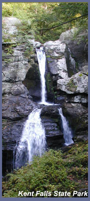
Kent Falls
State Park is located 5
miles north of Kent, CT on Route 7
and is probably the most known and
visited falls in the state of
Connecticut. The main
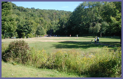
attraction is the falls,
obviously, but the park is a great
place to have a picnic, take in
some fresh air, throw a frisbee
around, or just people watch on a
busy day. There's a small trail
loop that goes up the falls, over
into the forest, and back again to
main parking area. Most just visit
the falls however. In 2007 Kent
Falls celebrated the new
landscaping and path leading up
the side of the falls. So
everything now is nice, safe, and
primed for great lookouts over the
falls. Unless there are
drought-like conditions, the
waterfall runs hard and if it has
rained substantially or if we get
a large snow storm late winter
followed by warm weather, the
blasting cascades put on a
spectacular show. Most of
the falls are not visible from the
road and just the last bit of it
from the parking lot. You'll have
to hike up a short but steep trail
to see it all. The path and
wooden lookouts are regularly
maintained which allows visitors
to climb right up along side the
falls all the way to the top for
post card views of the water. The
trail to the top is about a 1/4
mile and the vertical height of
the entire falls is around 150-200
ft.
This is not a long hike but does
go straight up and those with
asthma or heart problems should go
very slowly. But the trail is
accessible to nearly everyone. Children
should be watched carefully
since the excitement of the
falls can sometimes entice
little ones to get close or
touch the water. This is
extremely dangerous and there
have been some terrible
accidents at Kent Falls because
some are naive to the power of
the water.
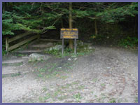
Surrounding the falls is a trail
loop which offer some nice views
and quiet forest walks. It's best
to look at the posted trail maps
to get an idea of the color codes
and how the trail is laid out.
It's not extensive but still
always smart to have an idea about
it before venturing in to the
forest.
There is a charge per car on
weekends and holidays ($7 for
Connecticut cars and $10 for out
of state cars) during the week it
is typically free. Between
November and April there may be no
charge on weekends as well since
the winter months don't get nearly
as much visitors. Charging a fee
they obviously are taking
advantage of the popularity of the
falls but it's also smart because
they can use those resources to
keep the park clean and supervised
at all times. It's a good deal all
things considered.
The hiking is nice but honestly
the waterfall is the big
attraction. A trail system of a
main trail plus red and yellow
blazed into the forest is there
for you (click on the link below
for official state park website
and download a map). If you like
to picnic next to a beautiful
waterfall, relax and people watch,
it's certainly worth the
investment of time to drive on up.
If you're a motorcyclist it's also
a great place to enjoy a natural
setting without worrying whether
your bike is going to be okay
while you're gone on the hike.
Memorial Day, 4th of July, and
many beautiful weekend summer days
it can get filled up in the
parking lot. Kent Falls is right
off Route 7 which is one of the
most popular scenic drives for
folks looking to escape southern
CT or metro NYC area. Visit the
official state park website for
telephone numbers to call for info
regarding Kent Falls State Park. Kent
Falls official website. The
phone number as of 2007: (860)
927-3238. If this link or phone
becomes outdated do an internet
search for Connecticut Department
of Environmental Protection to
find their official website. Once
at the website in search box type
in "Kent Falls State Park".
 Directions: Getting
to Kent Falls is really simple.
Take Route 7 north to Kent.
The falls is located 5 miles north
of the town center on the right hand
side of Rt. 7. (Slow down as you
near the 5 mile mark on your
odometer as the entrance is just
after a bend in the road and can
easily be driven by.) If you
are coming from above Kent, take
Route 7 to Cornwall and it's 3 miles
south on Route 7 from the
intersection of Route 4 and Route 7
in the town called Cornwall Bridge
("the" Cornwall Bridge - old covered
bridge - is a few miles north of the
4 and 7 intersection in the town
called West Cornwall right off of
Route 7. Why Cornwall Bridge isn't
in Cornwall Bridge the town? Good
question!). If you get lost.
Ask. Everyone in the
area knows Kent Falls and will have
no problem pointing you in the right
direction. Kent
Falls official website
Directions: Getting
to Kent Falls is really simple.
Take Route 7 north to Kent.
The falls is located 5 miles north
of the town center on the right hand
side of Rt. 7. (Slow down as you
near the 5 mile mark on your
odometer as the entrance is just
after a bend in the road and can
easily be driven by.) If you
are coming from above Kent, take
Route 7 to Cornwall and it's 3 miles
south on Route 7 from the
intersection of Route 4 and Route 7
in the town called Cornwall Bridge
("the" Cornwall Bridge - old covered
bridge - is a few miles north of the
4 and 7 intersection in the town
called West Cornwall right off of
Route 7. Why Cornwall Bridge isn't
in Cornwall Bridge the town? Good
question!). If you get lost.
Ask. Everyone in the
area knows Kent Falls and will have
no problem pointing you in the right
direction. Kent
Falls official website
If you have any trail updates to
share or have feedback/questions
please click
here to send email or call
203.788.7665
|