Seth Low
Pierrepont State Park
is just a few minutes from the
center of Ridgefield, CT and is a
wonderful place to escape for a
few hours. Though there may not be
spectacular views, sprawling open
fields, or rugged up hill climbs,
it's a neat little place with
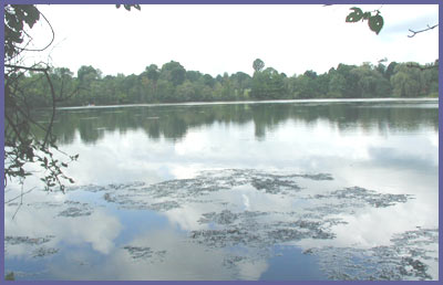
varying terrain. A good size pond
greets visitors and it's teaming
with life - your footsteps along
the shoreline trail will surely
cause many a frog, fish, or turtle
to leap, splash, scurry, jump. The
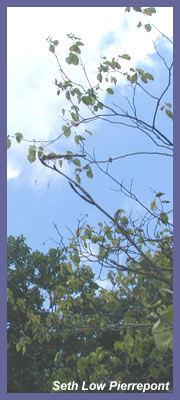
forest trees are tall and birds of
all types are right at home. Many
locals use Seth Low to kayak,
canoe, fish, swim, and escape into
forest. Neighborhood homes are
dotted along the water's edge or
close by so the initial shoreline
hike requires you to navigate past
frequented fishing holes, possibly
a recent teenage campfire spot,
and a backyard but you'll soon
disappear away from the hustle and
bustle as the trail takes you to
the far end of the pond. It's here
the forest takes and the trail
systems winds and loop way back
into the woods. There's even a
nice little overview which makes
for a good spot to rest and
recharge before exploring further
in or heading back to the car -
though it's important to point out
that the overview isn't grand or
spectacular (it probably once was
a magnificent view overlooking the
pond but the trees have matured
and grown so much over the years
that the pond view is completely
obscured).
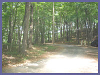
The trail begins at the parking
lot and you just follow the white
hash marks into the woods and over
to the pond's shore. Seth Low is a
popular place for those launching
paddle boats, fishing, and in some
spots has that feel of a hangout
(broken bottles, illegal
campfires, some littering).
Therefore, the first 5-10 minutes
of the hike is nice because of the
pond scene but you'll likely want
to get right past this stuff and
onto the more remote sections of
the trail. There's even a house
practically on the trail and you
almost feel like your intruding
but don't worry because you have
every right to be there and the
trail will quickly take you away
from the house. Once beyond this
stuff (which really isn't a big
deal at all) the trail really
comes to life. The far end of the
pond is very picturesque. Frogs,
fish, and turtles leap, splash,
and scurry as you approach them. Swans,
ducks, and herons are easily
spotted and obviously used
to people so it's not hard to get
a nice glimpse of them. It's
likely that folks will be out on
the pond fishing which adds a nice
touch to the scene. The day I
hiked, two separate
father/daughter groups were out on
small boats fishing and having a
great time.
Eventually the white trail makes
it's way into the forest. It's a
little swampy at first and
remember to carefully walk over
the wooden planks and bridges as
some of the boards seem a little
worn. It's always fun to listen to
the hustle and bustle fade off as
you make your way into the woods.
If you're visiting during the hot
days of summer bring bug spray
with DEET. I was there during a
hot August day and didn't have too
much of a problem but I wasn't
there early morning or evening
when mosquitos are most active. And
back in the main area I noticed
a sign that said West Nile Virus
has been found in parts of
western Connecticut and
mosquitos can spread the virus.
But this is just a cautionary
warning - it does not mean West
Nile is there at Seth Low...the
DEP by law has to post those
kinds of warning. Visit the DEP
West Nile page for more
information on how to avoid it.
But the tall hardwoods and lush
cover soon take over and leave the
swampy area behind, providing a
nice canopy for peace and quiet.
The water sounds fade out and the
chirping of birds and chipmunks
come into play.
A short distance into the
woodland portion, the white trail
meets the blue trail. The white
trail goes to the left and
continues along a woodland hike. The
blue trail goes to the right,
over a footbridge, and up to
the overview. It's not a difficult
hike but there is a very short
section of trail that is slightly
steep. Also along the way watch
for the big blue arrow painted on
a tree telling you the proper way
to go...it's a left turn and the
right turn the orange trail that
wanders into a different part of
the park (and don't forget that
on the way back, it's a right
turn at the orange/blue
intersection...stay with the
blue trail to make it back to
the white trail).
The view from atop the blue trail
is not spectacular but it's also
not hard to get to and a nice
little spot so I think it's worth
the effort to check it out. You
simply follow the blue trail as it
winds up a rocky part of the park
and eventually to a rock outlook.
Just watch your step up along
the steep part of the trail and
overview area as there as there
are some broken bottles and also
a few spots with some steep drop
offs - this is especially true
if children are hiking with you.
The
overview is a good place to
relax and have a drink or
snack. You can return the same way
you came or explore way back into
the woods as the trail system is
quite extensive back there but
with not major highlights to point
out - just the peace and quiet of
a nature walk - which ain't too
bad at all! There are other
options as far as hiking here and
to the overview. Visit Seth
Low's official state park page
and click on the map link
and print it out. Bring it with
you and create your own path and
options. It will help you prevent
from becoming lost or confused by
the different colored trails.
 Directions: From
the north (Danbury area) take
Route 7 then Route 35 to
Ridgefield Center. At Ridgefield
take a right onto Route 116 off of
Route 35 (past all the shopping
centers but before historic
downtown). From the south
(Fairfield or New Haven) take
Route 7 north to Route 102 and
follow Route 102 to Ridgefield
center. Take a right onto Route 35
and go through historic Ridgefield
with all the small shops, etc.
Bear left onto Route 116.
Directions: From
the north (Danbury area) take
Route 7 then Route 35 to
Ridgefield Center. At Ridgefield
take a right onto Route 116 off of
Route 35 (past all the shopping
centers but before historic
downtown). From the south
(Fairfield or New Haven) take
Route 7 north to Route 102 and
follow Route 102 to Ridgefield
center. Take a right onto Route 35
and go through historic Ridgefield
with all the small shops, etc.
Bear left onto Route 116.
From Route 116 it's 2.2 miles
exactly to Barlow Mountain Road.
Take a right onto Barlow (small
brown sign with boat launching
symbol is visible). A short
distance down this road is a stop
sign. Look over to the left and
you will see the sign and entrance
for Seth Low Pierrepont. Drive
over and park in the dirt lot
making sure not to block anyone
from entering, parking, or
leaving. White trail markers are
clearly visible on the trees. Head
on in.
http://dep.state.ct.us/stateparks/reserves/sethlow.htm
is the official website and they
have their own driving directions.
Printable
version of the Seth Low
Pierrepont State Park page
If you have any trail updates to
share or have feedback/questions
please click
here to send email or call
203.788.7665
|