If you live in or around Newtown,
Connecticut, Upper
Paugussett State Forest
has a great 6-mile round trip hike
nestled in amongst suburbia and
the banks of the Housatonic River.
It might surprise you if you were
familiar with that part of town
that such a trail would exist. As
you near the entrance you may have
that feeling of wandering down a
neighborhood dirt road leading to
nowhere or trespassing. But if you
just poke in to wade through some
back roads and beyond the houses
you'll emerge into a little dirt
parking lot with no trail head in
sight, possibly confusing you even
further! But you're okay once you
see the Pauggussett State Forest
sign and what lies ahead is a
surprisingly challenging trail
with a nice variety of terrain and
highlights that will have you
recharged upon returning to your
car. You can tackle the whole loop
or cut the hike short using trail
shortcuts along the loop that lead
back to the car. You can just walk
down to the river's edge for a
short hike or disappear for a few
hours. Either way a serene forest
and river hike awaits and what it
lacks in overviews is made up for
with a feeling of disappearing
into another world. It should be
noted before you head there for a
hike that the place is sort of a
multi-use destination. It's
actively harvested for wood so
logging is ongoing. Hunters
definitely use this spot during
the winter's hunting season and
some mountain bikers use the
logging road that may intersect
cross over a hiking trail or two.
Hiking season is limited by two
things: winter hunting and eagles.
The state forest seems to be a
popular spot for hunters during
winter as shotgun cartridges
litter parts of the main logging
roads that cut through the forest,
and for most of the winter the
river walk portion of trail is
closed to allow bald eagles a
chance to nest in their winter
spot. Paugussett seems to be a
nice blend of accommodating hiker,
hunter, and logger. It's a working
forest and is micro-managed quite
a bit. Which is a good thing in
this case otherwise one group or
another might overrun the place
and ruin it. It's a nice mixture
of conservation, recreational use,
and natural wonder.
From the car you can hike off in
3 different directions. A wide
logging road is obvious and it
cuts right through the middle of
the forest which partitions the
area into "water hike" or "forest
hike". If you look back to the
left and up into the forest from
the parking lot, you'll notice a
blue blaze trail. Paugussett is
part of the Connecticut Forest and
Park Association
(http://www.ctwoodlands.org) which
maintains the state's blue trail
system. This blue blaze trail
heads off into the western part
and is all forest hiking. If you
know you want to hike the entire
6.1 mile loop then starting there
is a good choice. However if
you're not sure about tackling the
whole thing then the best bet is
to walk back down the road a few
hundred feet and catch the blue
trail as it heads left and down
into the forest leading you
towards Housatonic River bank.
Most people should choose this
route since it's the quickest way
to see the best of the trail and
will allow you to plan out a hike
that could be very short, medium,
or the long 6 mile loop. Be sure
to check out the trail map before
venturing in so you have an idea
of what lies ahead for you. The
trail description below follows
the trail down to the water first
then through the forest.
If you're having trouble finding
the blue trail as you walk along
the road just note that the old
barn at a residence is directly
across the street from it. Use the
barn as reference to find the
trail head. The first blue hash
mark is on a tree. You may notice
thick blue plastic piping and
large metal bins in the woods
across the street from the trail.
The park allows someone to harvest
tree sap which produces maple
syrup. It's a conversation issue
but also benefits several parties.
The person running the system can
produce and sell the syrup which
in turn produces profits for the
park to help maintain itself. It
allows scientists to keep an
ongoing field test,
children/groups to learn about
nature, and of course people wind
up with some mighty tasty syrup on
their pancakes!
Heading down the blue trail
towards the river is easy enough.
The trail follows along an old
stone fence that marks a boundary
between park and private property.
It meanders down and soon puts you
in that classic Southern New
England forest canopy. An acoustic
wonder in that it just seems to
push off modern day noise allowing
the hiker to feel the peace and
quiet they seek on such hikes.
It's a good warm up for the
journey to come. Fairly soon
you'll see the river and you'll
want to note the trail goes to the
left (in winter this portion of
trail could be closed due to
nesting bald eagles so don't
ignore the warning if it's posted
since it's critical to the eagles'
survival and animals like this are
so rare in these parts so it's a
treat just to have them around and
worth the extreme measure to keep
them coming back). If you choose
to walk up to the water instead of
going left with the trail, it's
not really officially part of the
trail. It's more a hangout for
fishermen angling into the
Housatonic or possibly the
occasional teenagers. LOTS of
broken glass unfortunately so it's
in your best interest to bypass
this area and hang a left on the
designated trail. It will reward
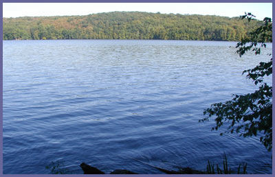
you with much better river views
than the broken bottle spot. Ahead
lies the next 3.1 mile of trail.
The trail meanders up and down
from this juncture with dense
hardwood forest on your left and
soft river views on your right. If
you look up into the trees at
times you may spot an owl, hawk,
or even an eagle if you're lucky.
It's a perfect perch since they're
protected by the forest canopy but
have easy access to look out over
the river. The old dam system off
in the distance helps to create
Lakes Lillinonah and Zoar. There
are times where the trail rises up
high over the river and is quite
rocky so pay attention in these
sections as it would be possible
to slip and tumble over if you
weren't hiking with common sense.
It's tempting at times to poke in
through the trees and stand on
spots off trail but doing so
creates trail erosion and more
importantly possibly a turned
ankle or serious fall. So hang
loose on the trail as it takes you
along the banks of the river and
eventually up and away from it
into the beautiful hardwood forest
highlighted by the tall pine trees
that once dominated North America
but now relegated to small parcels
of land. Towards the end of this
river section is a spot to look
out over the river well away from
any signs of modern life. If not
for the occasional boat in warm
weather season this spot could
easily be a scene from colonial
New England. It's a bummer to see
river debris "litter bug"
mentality since the shores of the
Housatonic receive a tremendous
amount of man made garbage
requiring large scale cleanups
throughout the year - mostly
volunteer efforts. In spite of the
human intrusion it really is a
wonderful spot to have a snack or
snap off a photo before heading on
for the rest of the hike.
As you hike up and away from the
water the trail does get steep at
times but it's more a gradual
climb than a difficult incline. It
switches back and forth and there
could be side trails to the left
but stay with the blue trail and
resist the desire to explore other
trails since they may take you
back to the car before you want
to. It's really nice in here.
You'll forget you're surrounded by
the suburban neighborhoods where
Brookfield and Newtown meet. Don't
forget to stop in here and be
perfectly still. It's about as
quiet as you could get in this
region and the trees truly are
majestic. After a good bit of
forest hiking a beautiful old tree
with a trail log book suddenly
appear ("Letterboxing" is a
popular hobby for some. They like
to find various sign-in boxes
dotted throughout the states
forests and trails). It's a cool
spot and be sure to read some of
the entries as well as jot down
your own for fun or if you've seen
something that you think other
hikers would want to know (animal
sighting, tree damage, etc.). At
this point you have a choice.
You're halfway so you can cut
through the middle of the park
using the white trail that leads
to a logging road which takes you
right back to your car. To find
the white trail, as it may be
tricky for some to see, stand
looking at the old tree with the
log book, then look right. In that
direction you'll pick up the white
hash marks on the trees as well as
some active logging or remnants of
it. Follow the white trail to the
logging road intersection and just
keep straight back to the car.
 If
you're feeling good then you can
continue on the blue trail to
discover the other half of the
forest and eventually make your
way right back to where you
started. Hiking the rest of the
loop is more of the same without
the river portion. It's a great
hike through there but there
aren't any major highlights you'd
miss if you're feeling a bit tired
and looking to head back to the
car. If you do take the white
trail shortcut back towards the
car stay with it until it comes to
a logging road intersection. Go
across the logging road
intersection staying straight all
the way to the car. Don't be
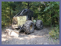
alarmed if you come across logging
monsters such as this unique
machine pictured here! If
you're feeling good then you can
continue on the blue trail to
discover the other half of the
forest and eventually make your
way right back to where you
started. Hiking the rest of the
loop is more of the same without
the river portion. It's a great
hike through there but there
aren't any major highlights you'd
miss if you're feeling a bit tired
and looking to head back to the
car. If you do take the white
trail shortcut back towards the
car stay with it until it comes to
a logging road intersection. Go
across the logging road
intersection staying straight all
the way to the car. Don't be
alarmed if you come across logging
monsters such as this unique
machine pictured here!
Whether you are looking for an
easy hike, good workout, or just
to disappear for awhile Paugussett
State Forest in Newtown has what
you're looking for. It's not an
amazing draw dropping experience
but is absolutely worth every step
you'd ramble along. It's
surprisingly good for a spot so
close to suburban homes and a
popular river front. And don't
under estimate the trail. The
entire loop is quite the workout
for what it is. You'll sleep well
the night following your
Paugussett adventure.
NOTE: Parts of this trail can be tricky for first-timers due to old logging roads and such. It's important to stay on trail following trail markers.
Map printout from official state website.
 Directions:
Getting to Upper Paugussett
(remember that there is Lower
Paugussett and it's totally
different from this one so if
you've done your own internet
searches don't confuse the two)
should be easy since it's right
smack in the middle of Newtown and
near bordering Brookfield. But the
road systems near the forest can
be very confusing so the best bet
is to use online maps such as
Mapquest, Google, or Yahoo and
type in "99 Echo Valley Road
Newtown, CT". This will give
driving directions to the end of
Echo Valley Road and parking lot
for Paugussett State Forest in
Newtown.
Most people will take Interstate
84 to exit 10 in Newtown. At the
end of the ramp drive a hundred
feet up the road in the opposite
direction of all the gas stations
and diner and look closely for
Walnut Hill Road (easily missed if
you're driving too fast). If
you're driving WEST on I-84 then
it would be left turn at end of
exit 10 ramp and almost immediate
left onto Walnut Hill. If driving
EAST on I-84 then it would be
right turn at end of exit 10 then
up the road a bit for left turn
onto Walnut Hill Road. Follow
Walnut Hill Road as it winds up
and down and around a curvy road
until Alberts Hill Road. Bear to
the left and take Alberts Hill
Road all the way until it ends at
Echo Valley Road and the tiny
intersection where Sanford Road
also starts. Just take a right
onto Echo Valley from Alberts Hill
and it will become a narrow dirt
road and end at Paugussett State
Forest dirt parking lot.
Print
out Paugussett State Forest
page
If you have any trail updates to
share or have feedback/questions
please click
here to send email or call
203.788.7665
|