The
Story of the
Dorothy
Frances Rice
Sanctuary
It's up in
the wilds of
Peru, aptly
named for its
2,043-foot
average
elevation,
highest in the
state. Here
you can find
total
solitude,
tranquility
and unspoiled
beauty.
Dorothy
Frances Rice
Sanctuary is
nearly 300
acres of
woodlands,
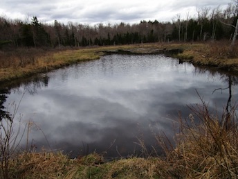
meadows and a
pond for
everyone to
enjoy. Decades
ago, it was
used for
several years
as a research
headquarters
and summer
residence for
several Smith
College
students.
Smith College
is in nearby
Northampton.
The
sanctuary was
established in
the late 1920s
on property
owned by Oran
Rice, a New
York City
architect, and
his wife,
Mary, to honor
their
daughter, a
recent Smith
College
graduate who
had succumbed
to
tuberculosis.
Dorothy
Frances loved
this land, the
site of her
family's
summer home.
After Oran
Rice died, his
widow set up a
family trust
to preserve
and maintain
the land,
which was
donated to the
New England
Forestry
Foundation in
1974, along
with a
maintenance
fund for the
trails and the
caretaker's
cottage. The
family's
summer home
within the
preserve had
been destroyed
by fire and
later was
demolished.
After a
brief walk on
Rice Road into
the property
(the road is
closed to
vehicles), a
clearing
reveals the
former
caretakers
cottage, a
wishing well,
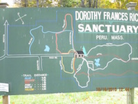
and an array
of trail maps
nearby. A
notebook
invites
visitors to
record their
observations
of flora and
fauna.
There are
six colored
trails well
marked and
maintained by
three
volunteers.
The red,
white, orange,
blue, yellow
and pink
trails are
clearly marked
with signs and
arrows, so
there's no way
to get lost,
even though
the wilderness
area feels
remote and
isolated.
The
well-detailed
maps at the
gate and the
cabin area aid
in navigating
the trails,
each of which
is a half-mile
to one-mile
long. Visitors
can sample the
preserve in an
hour, or spend
a morning or
afternoon
hiking all the
trails. The
Red Trail also
honors the
late Stephen
J. Phillips, a
Peru resident
(1947-1995),
who had served
with
distinction in
the U.S. Navy
during the
Vietnam War. A
short path
leads to a
plaque flanked
by small
American
flags. What
better
memorial for a
loved one than
to preserve
land and open
it for public
enjoyment?
VOLUNTEERS
ARE ALWAYS
WELCOME TO
KEEP THE
TRAILS CLEAR,
& MARKED.
CONTACT:
djdcampbell55@gmail.com
or
mlcampbell56@gmail.com,
413-684-0176
 Directions:
: From
Williamstown:
Follow Rt. 2
East to North
Adams. After
the bridge
(over the
Hoosac River)
and a traffic
light, there
is Shell
station (on
left) and
Notch Rd. (on
right--Mt.
Greylock
Reservation
sign) make a
right onto
Marion Avenue.
If coming from
the east
Please note:
The directions
were provided
by a resident
on this
street. They
often deal
with stressful
situations
regarding
parking and
trail access.
In the spirit
of good
sportsmanship
please take
the following
advice from
the
neighborhood
to heart for
the sake of
those that
live there.
Thank
you!
"This is a
residential
street that
narrows
towards its
end and
becomes a
private
driveway. The
parking is
limited to two
or three cars
off the road
on the right.
On the
weekends it is
best to park
around the
median in the
block before
where the road
becomes
two-lane again
at Pershing
St. Otherwise
it is very
difficult to
turnaround and
cars and
private
property have
been damaged
in the
process. The
trailhead is
accessed by
walking to the
end of the
street then on
the right side
of a split
rail fence
along the edge
of Notch
Brook. The
residents
request no
gathering at
the trailhead.
This is our
neighborhood,
not a public
parking lot."
Printable
version of the
Cascades Trail
page
If you have any trail updates to
share or have feedback/questions
please click
here to send email or call
203.788.7665
|