(Use this page to print out the hike. Click the back button to go back to the webpage - www.berkshirehiking.com)
The locally-famous "Snowhole" is nestled in the portion of the Taconic Mountain Range where MA, NY, and VT come together. This rare, and intriguing geophysical treasure is essentially a 40-50 foot deep bedrock chasm that holds snow and ice well into the warmest summer months, and as of July 14th, 2004 continued to hold a fair amount of ice as it probably has done for thousands or millions of years gone by. If you'd like to really get adventuresome, there is also an explorable cave situated just at the beginning of the descent into the "snowhole" with room for up to a half dozen adults. The small entrance is on your right and is partially disguised by surrounding rocks. Bring your flashlight and wear "Mud clothes" as this cave will require you to get dirty if you wish to explore it. WORD OF CAUTION: Proper caving equipment and practices should be adhered to at all times, and NEVER ENTER THIS CAVE ALONE! If you have an interest in caves, or if you are just looking for a really cool new place to explore this summer, this spot comes with the highest of recommendations!
En route to the snowhole, take advantage of the numerous scenic vistas, and well maintained trail system to make your trip to the snowhole as enjoyable as the destination itself. This trail system is maintained by the Williams College Outing Club as a part of the College's Hopkins Memorial Forest and by the State of New York. The start of the walk from the parking area is fairly steep, but very short, and once you arrive at the small clearing and sign for Hopkin's Forest you have conquered the most difficult part of your trip. From that point you should follow the Taconic Crest Trail, marked by trail markers consisting of a white diamond on a blue square background, over gently rolling terrain for approximately 1-1.5 hours passing the Shepard's Well and Birch Brook side trails along the way. At the end of one of the open areas/scenic vistas you will see a sign that says "White Rocks" and from that point you continue for about 10 more minutes to a side trail on your right leading to the snowhole. Note: Some maps list White rocks much closer to the parking area, but they are inaccurate! These directions have been field checked, and "Berkshire" approved! From this clearing and sign, you will take your next right onto a small side loop that leads to the Snowhole and back again, if you miss the first, you can take the second, or vice versa.
Although there are several ways to access the snowhole, the route I describe here has been selected for it's moderate approach trail, abundance of parking, views, and wild berries, as well as it's simplicity for those of you who may be less than proficient map readers!
(The trail description and photographs on this page are courtesy of Ryan Auge'. Ryan runs hiking/snowshoe tours and shuttle services all year round at Saddleback Trading Post in North Adams, MA. I highly recommend him if you ever want to visit this hike or any other in western Massachusetts. Great guy, friendly, good rates, knowledgeable, experienced, and safety conscious. Mention that you found him via Berkshire Hiking, and all in your group get a complimentary snack and drink.) ryan@saddlebacktradingpost.com 413.664.2772
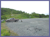 Directions: From Rt. 7 in Williamstown, MA: Turn onto Rt.2 west at the Taconic Park Restaurant approximately half way between the Store at Five Corners and the Wlliams Inn. (This road is known locally as the Taconic Trail.) When you reach the top of the hill you will enter the town of Petersburgh NY, and you'll come to a large parking area on your left. Park there, and cross the road to access the trailhead. The trail entrance can be hard to see if you've never looked for it, but it's there, I promise! You will then hike the short steep section I described earlier, and you're on your way!
© Berkshire Hiking 2004